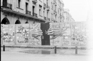
A hole big enough for a person to pass through rips through the iron sculpture in Beirut’s central Martyrs’ Square.
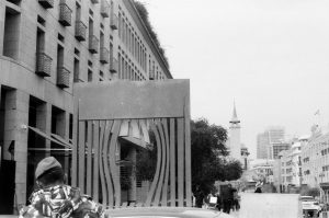
“the wall of hope” by Hady Sy
The sculpture’s location is significant, explains a plaque on its base. Those who pause to read it as they pass by through one of Beirut’s most expensive enclaves will learn that this spot marks a point on the old city’s periphery, where walls and a deep moat once enclosed the 9th century iteration of Beirut, protecting it from enemies.
A line extended from the same point to separate Beirut into opposing sides during Lebanon’s Civil War. During the national discord that divided the country from 1990-1975, “the Green Line” marked a no-go-zone for the country’s conflicting sects.
According to the plaque, the sculpture itself reflects the dream of a world without borders, a world that resists “intolerance, hatred, and fear, resonating with Beirut’s spirit of openness toward people, ideas, and creation.”
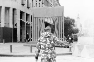
Now, amid a wave of popular protests that have overturned Lebanon’s government, the spot is ever stronger in its symbolism. Temporary blast walls erected alongside the sculpture surround the houses of Parliament, partitioning the country’s government off from the protestors who have gathered outside to demonstrate since October, 2019.
government buildings in central Beirut are currently walled off against demonstrations
The sculpture and the concrete slabs surrounding it are testament to how political change and the passing of time take their toll on the city’s physical character.
Shifting political relationships have played their role in shaping the whole country. After the fall of the Ottoman Empire in 1922, the region was carved up by new imperial powers under the Sykes-Picot Treaty, which handed the five Ottoman provinces which make up modern-day Lebanon over to the French Mandate on the pretext of the French helping to shape new national institutions. The lines drawn on the map then remained after Lebanon gained its independence in 1943, and persist until today.
Later, Lebanon was reshaped by the tide of economic liberalism which swept across the world in the sixties and seventies. In A History of Modern Lebanon, Fawwaz Traboulsi has described how wealth was concentrated on the coast in Beirut, pulling people to leave the poverty it induced in the countryside and to gravitate toward the capital, inhabiting new urban neighbourhoods. Traboulsi describes “a poverty belt” tightening around Beirut, both in the physical sense as suburbs expanded on the city outskirts, and politically as the country’s disadvantaged were pushed to breaking point.
Migration to cities added tensions to the country’s political architecture, as new urban dwellers were still required to vote in the villages where they were born, and felt robbed of the chance to participate in the local policies and services that were shaping their surroundings.
The researcher Yusef Sayegh has also described how sectarian patterns of ownership meant that by the 1970s Lebanon’s Christians predominated over trade, commerce, industry and services by a ratio of 5:1, while their management meant that agricultural areas in the south became unsustainable for labourers. Traboulsi adds that the conditions contributed to Shia Muslims building a “structured and official sect” in Lebanon in 1967, committed to “improving its social and economic conditions.” The sect would go on to make the greatest political gains of any group in the civil war, fighting from the western side of the Green Line.
Likewise emanating from the Skyes-Picot Agreement, the Israel-Palestine conflict playing out over Lebanon’s border played its part in shaping the geography of its northern neighbour. Repeated incursions by Israeli forces over the southern frontier led Palestinian refugees previously settled in the south to flee to camps Beirut, the majority of them in the city’s west.
Skirmishes broke out between Lebanon’s extremist Christians and the new city-dwelling Palestinians, and an exchange of fire ultimately sparked civil war.
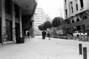
Much of the area of Beirut surrounding the Green Line was destroyed in the Civil War. Private companies were largely responsible for rebuilding damaged areas in downtown Beirut in the nineties, and most significant among them the Lebanese billionaire Rafic Hariri who would later become prime minister. The reconstruction only built another kind of monopoly, creating personal profit, a pristine city centre and political ascendancy for an elite who can now be found walling themselves in against those whom they have disenfranchised. With a metaphorical symmetry, protestors have ripped stone cladding from pillars in reconstructed downtown Beirut to use in their clashes with the security forces.
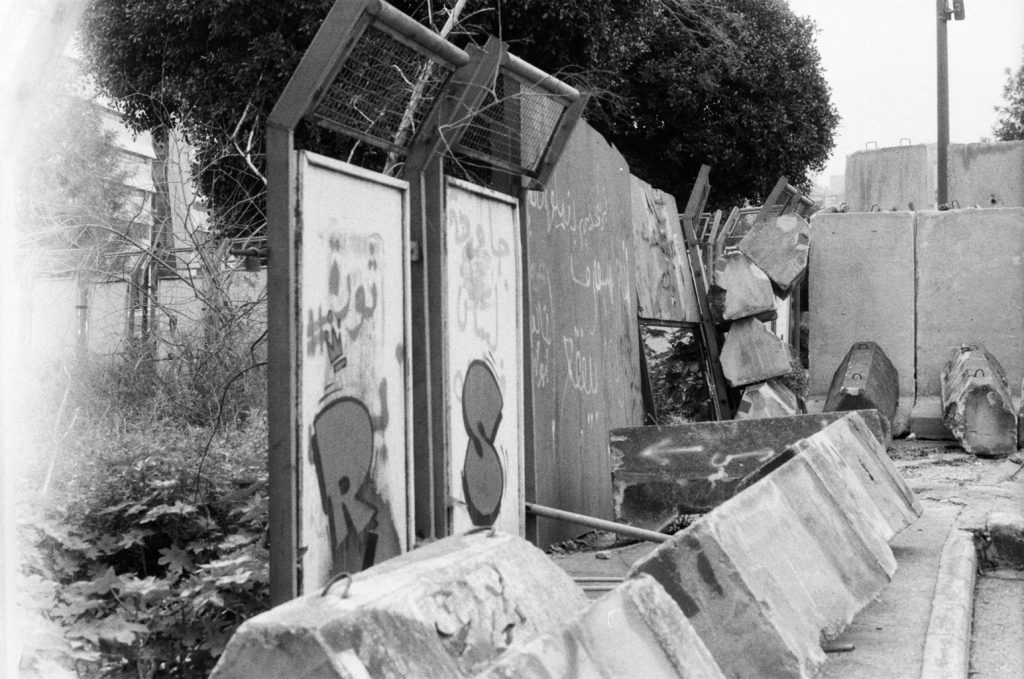
In attempts to deflect protesters from the halls of government, the army and police have used concrete walls, while at times aggressors suspected to be on the payroll of Hezbollah have deployed violence against them. In turn, protesters have blocked off primary roads in the country, a assertion of collective power over the geography of Lebanon to stopper the arteries of the economy, and draw attention to their political demands.
Instead of a divisive “Green Line,” protesters’ chants now dub the right of the people “a red line,” as they lay down their limits in front of the governing forces.
يقبع تمثال في ساحة الشهداء في بيروت يتكون من صفائح حديدية مثقوبة في الوسط، حيث أن الصفائح الحديدية التي في المنتصف مقصوصة لتكون ثقب كبير يسمح بمرور انسان. تشير اللافتة المعلقة عليه أنه موضوعٌ في موقعِ تاريخي في المدينة، حيث كان يطوق بيروت القديمة منذ زمن بعيد جدار وخندق مائي لحماية المدينة من غارات الأعداء في القرن التاسع.
بالإضافة للسياق التاريخي، فلقد أصبح الموقع ذاته بعد قرون يقسم بيروت إلى نصفين أثناء الحرب الأهلية، التي طالت من 1975-1990، حيث كان يفصل الطوائف المتنازعة في بيروت بعضها عن بعض. ولقد كان يسمى في فترة الفتنة تلك بـ”الخط الأخضر”.
تشير اللافتة إلى رمزية التمثال، على أنه يعكس الحلم بعالم بلا حدود، مقاوم للتعصب والكراهية والخوف، ويبين، بحسب اللافتة، روح بيروت التي ترحب بجميع “الناس، والأفكار، والإبداع”.
وفي الحاضر لم يفقد بعد الموقع قوته الرمزية، حيث يقف على جانب التمثال الكثير من الجدران الواقية من الانفجارات الموجودة مؤقتا بوسط العاصمة، المحيطة بمجلس الشعب.فهنالك جدران عسكرية تفصل متظاهري البلد عن حكومتهم، وتعلن المعركة الجديدة الجارية في لبنان.
تغيّر الطبيعة السياسية لكل عصر جديد يؤدي لإعادة تشكيل المساحة الجغرافية، فعند سقوط الامبراطورية العثمانية في العام 1922 واستيلاء الانتداب الفرنسي على الحكم في الولايات العثمانية الخمس، التي أصبح يتكون منها لبنان اليوم، بحسب تقسيمات اتفاقية سايكس بيكو والتي تم تأييدها لاحقًا بقرارات من عصبة الأمم التي صدرت عام 1920، والتي أجازت نظام الانتداب على المناطق العثمانية المتفككة بحجة المساعدة في إنشاء مؤسسات للدول الجديدة، وهو ما شكّل الحدود الجغرافية للبنان حتى يومنا هذا، بعد استقلال لبنان في العام 1943.
تركت موجة الليبرالية الاقتصادية التي اجتاحت العالم في العقدين السادس والسابع من القرن المنصرم بصمتها على لبنان، وفقًا لِما كتبَه فواز طرابُلسي في كتابه “تاريخ لبنان الحديث”. تركزت ثروةُ الدولةِ في بيروت، وأدى الفقر لترك المواطنين للأرياف للعيش في المدن لتكوين ساحاتٍ عمرانية جديدةٍ في محيط بيروت .
يبيّن طرابلسي في كتابه بأن “حزامًا فقيرًا” أصبح يحيط ببيروت حينذاك، إثر الزحف السكاني للبنانيين من الأرياف للسكن للإقامة في ضواحي بيروت. وهو ما يشير، بحسب طرابلسي، إلى تأثير الاقتصاد على التوزيع الجغرافي. كما وأدى تزايد أعداد العمال القادمين إلى بيروت إلى مشاكل جديدة في النظام السياسي؛ حيث اضطر السكان الجدد في المدن، في بيروت على وجه الخصوص، للتصويت في الانتخابات البرلمانية في الأرياف في مسقط رأسهم، بدلًا من المدن التي يسكنونها، وهو ما جعلهم عاجزين عن المساهمة في وضع السياسات والخدمات المحلية في المدن التي كانوا يسكّنوها.
من جهته يقول الباحث الفلسطيني يوسف الصايغ في بحثه الذي بعنوان “…” حول هذا الموضوع، بأن احتكار المسيحيين للتجارة والذي أدى بدوره آلى تمركز الاقتصاد ورأس المال في بيروت، وخسارة الجنوب لثرواته إثر انتقال الثروة وتمركزها في العاصمة، ساهم أيضًا في تكاثف الشيعة وتنظيمهم لأحوالَهم المادية وتشكيلهم لقوات سياسية فعالة؛ حيث قامت قوات الأمل الشيعية بدور محوري في الحرب الأهلية على الطرف الغربي من الخط الأخضر.
كما وكان للصراع الفلسطيني الإسرائيلي دور مهم في تشكيل جيوغرافية لبنان؛ حيث أن تكرار القوات الإسرائيلية لغزو جنوب لبنان أدى إلى خسارة الكثير من اللاجئين الفلسطينيين الذين كانوا يقيمون في الجنوب لبيوتهم ومساكنهم، وتهجيرهم للسكن في مخيمات بيروت، التي يقع أغلبها في غرب الخط الأخضر. وهو ما أدى إلى انفجار الكثير من النزاعات بين اللبنانيين المسيحيين المتعصبين والفلسطينيين السُّنة، ونتج عن تبادل اطلاق النار فيما بينهم اندلاع الحرب الأهلية.
وكان من حصيلة ذلك هدم الكثير من المباني في نطاق الخط الأخضر أينما كان تركز المعارك. والتي أعاد ترميمها بعد نهاية الحرب الأهلية رجل الأعمال والملياردير اللبناني رفيق الحريري في التسعينات، حين أصبح رئيس الوزراء، وهو ما يعزوه الكثير من اللبنانيين لتحقيق الأرباح الشخصية، وشكل أخر من الاحتكار السياسي للحيز العام في لبنان. شاهدت في الشهر الماضي هدم الكثير من عواميد المباني التي بناها الحريري من قبل المتظاهرين اللبنانيين لاستخدامها في اشتباكهم مع القوات الأمنية.
بينما كانت القوات الأمنية تحاول أن تكون حاجزًا بين المتظاهرين والمنشأت الحكومية في وسط بيروت، من جهتهم قام المتظاهرون بقطع حركة السير واستخدم قوتهم في الحشد والتظاهر لإيصال صوتهم ودورهم في هندسة الشؤون الاقتصادية والسياسية والجغرافية في لبنان.
أصبح “الخط الأحمر” الذي يظهر في هواتف المتظاهرين يأخذ مكان الخط الأخضر الذي كان محوريًا في الحرب الأهلية، كما أصبح لدى المتظاهرين الجرأة والقدرة ليقرروا ما سيقبلونه أو يرفضونه من أفعال وتصرفات النظام القائم، هاتفين “حق الشعب خط أحمر”